Saturday, 3 August 2013

ARCHES, CANYONS AND MONUMENTS

MY TRUSTY CREW
LANDSCAPE ARCH
NEWSPAPER ROCK
ST. JUAN RIVER AT GOOSENECKS
TRYING TO GET RUN OVER
MODERN NAVAJO STEED
NAVAJO WOOL SPINNER
MONUMENT VALLEY
On the morning of our second day in Moab, a few of us decided to go rafting in the Colorado River. We joined up with a few other adventurous tourists to make a group of nine and, along with our guide Mackay, climbed onto an inflatable raft. Together, we spent about two hours paddling a stretch of the Colorado which included four rapids graded 1 to 2. It wasn't exactly white-water rafting but more a case of brown-water since the river was so muddy. It was great fun and I managed to keep my camera dry, but not the rest of me.

After lunch we took some short hikes around Arches NP to see further interesting rock formations. These formations are typically named after things they look like. We walked the Park Avenue Trail past 'Three Gossips' and 'Sheep Rock', then stopped by 'Balanced Rock' before hiking Devils Trail to 'Landscape Arch'.

We were back at our campsite late afternoon. It was Angela's and my turn to cook for everybody again so this time we prepared beef stew. The hot food, cutlery and plastic crockery were then packed for transportation and tour leader Alex drove us up to a viewpoint called 'Dead Horse Point'. From there we could look down upon the Colorado River and the surrounding sandstone rock formations from a great height. We were able to enjoy our food as we watched the colours of the rocks change from brown to orange as the sun set.

Next morning we ventured out from our camp to the 'Island in the Sky' district of Canyonlands NP to do a number of short hikes.

Island in the Sky is a mesa with an average elevation of about 6,000 ft, 1,500 ft above the immediate surroundings, enabling great views to be obtained from anywhere around the rim. We walked a short trail to Grand View Point Overlook from where we could see a vast rocky panorama. It rained for a change, and there was lightning in the distance, but it was still plenty warm enough.

After driving to a different location on the mesa we walked to Upheaval Dome, which is actually a crater, possibly caused by a meteorite.

Our third hike of the day was to Mesa Arch, which is a sandstone arch much like we saw in Arches NP, except that this one is hanging on to the side of the mesa wall. There is a large crack where the arch joins the wall, making it look extremely unstable. Inevitably the whole arch will drop into the canyon one day. In spite of this, some of the more brave/foolhardy of the group climbed onto the arch for photographs.

Back at the campground, the rain returned in the evening to challenge Kate and Chris, whose turn it was to prepare supper. The evening became cooler so, after the rain stopped, Alex lit a campfire so we could warm ourselves and cook marshmallows.

It was time to break camp in the morning and leave Moab for good. By 9.00am we were on our way to Monument Valley which straddles the border between Utah and Arizona. Along the way we stopped at the HOLE N" THE ROCK, which is a huge man-made cave alongside Highway 191. The cave is used as a watering hole and a home, and is surrounded by novel sculptures made of scraps of metal welded together.

We also deviated to Indian Creek to visit Newspaper Rock where drawings (petroglyphs) have been scratched onto the flat surface of the rock.

We had lunch at Muley Point on the southern rim of Cedar Mesa, overlooking the Valley of the Gods with the St. Juan River meandering through it. We obtained a much closer view of the River shortly after by driving down the steep exposed road from the mesa to the view point in Goosenecks State Park.

Once we had passed the town of Mexican Hat, named after a nearby rock, we had entered Navajo Nation territory. Monument Valley is wholly within the Navajo Nation, so to see it close up we needed to go to the Navajo Nation Visitor Center first.

They had an interesting display at the Center about the Navajo Code Talkers who used Navajo words to add a further layer of complexity to coded messages exchanged during WWII. Used in the Pacific theatre, these codes were never broken by the Japanese, giving US troops a significant advantage.

The viewing platform at the Visitor Center enabled us to obtain some excellent photographs of the mesas, buttes and spires which Monument Valley is so famous for and are seen in many cowboy films.

We were introduced to our Navajo guide Jamie who would take us on a 2-hour ride on unmade back roads around Monument Valley. We climbed aboard a specially modified 4WD vehicle with raised open seating on the back - a bit like a small open-top bus with no windows. It was a bumpy ride, but fun, and Jamie would stop every so often to give us the names of the various rock formations, which looked at their best in the low sun of the evening.

He took us to a traditional Navajo house, called a Hogan, made of wood and mud. A Navajo woman inside demonstrated carding and spinning wool. We also went to a cave called Big Hogan, the size of a music hall, where Jamie sang and played traditional Navajo music to us. I found the music really relaxing. Jamie tried to teach us a few Navajo words, but I have forgotten them now. He was an amusing guide with a laugh like Woody Woodpecker, so he deserved the tip I gave him at the end.

As it was getting late, we had supper at the Visitor Center. I had a Navajo Taco, which was large, filling and very similar to Mexican food I have eaten. Afterwards, Alex drove us to our Motel in Kayenta, Arizona. Luxury again!

Wednesday, 31 July 2013

UTAH

SPOT THE MAN IN SKIS
THE TEMPLE
SISTER MISSIONARIES AT TEMPLE SQUARE
DELICATE ARCH
We left Jackson at 7.30am to drive south roughly along the Wyoming/Idaho state border to Utah. Our destination was Salt Lake City (SLC), founded by the Mormons (Church of Jesus Christ of Latter-day Saints). Fellow traveller Katy teaches History at her school and is a bit of an expert on how the Mormons became established, so she has already given me some background information.

Before we got to SLC, however, we stopped for lunch at Utah Olympic Park, 28 miles east of the City. The Park was built for the 2002 Winter Olympics and continues to be used for training and competition. 

We stayed at the Shilo Inns Hotel in SLC, which was a welcome upgrade from the tent. After depositing my bags in my room, I walked to the famous Temple Square to see the buildings and find out a more about the origins of Utah State and the Mormon faith. Once I had toured the Temple, the Assembly Hall and the Tabernacle, two charming young ladies, Sister Missionaries, sat down with me to explain the differences between the Mormon and the Anglican versions of Christianity. They were very open in answering my many questions and didn't avoid the awkward ones.

I then continued my walk to the fine Capitol Building which overlooks the City from the hill. The lack of any need for security checks on entry surprised me because with every other government building I have entered, security guards have either searched or x-rayed my rucksack, and sometimes even got me to empty my pockets and walk through a metal detector. Here I just walked straight in the building to see a beautifully marbled interior with lots of informative displays.

On my walk back to the hotel I passed through the Creek Centre, which had a fountain that danced to music and also projected gas flames to accompany the water jets. It was brilliant.

SLC is in a beautiful location so I can see why Brigham Young said "This is the right place" (you will have to Google this to find out more). It is clean and seems safe, even late at night, but I was surprised that in a City with a dominant Mormon population there were still many homeless people sleeping on the streets.

I was also surprised to find that the City virtually closed shop after 9.00pm so I couldn't find a place to eat and had to make do with the two oaty bars in my rucksack for supper.

After a compensatory free breakfast in the Hotel next morning we headed off to the City of Moab, still in Utah, our base for visits to Arches National Park 5 miles away and Canyonlands National Park 32 miles away. Not surprisingly, the terrain became more desert-like as we drove south.

We arrived at the campground in Moab late afternoon and had an early supper. This was so we could do an evening hike in Arches NP. We would be staying at this campground for three nights.

There are about 2000 natural sandstone arches in the Park and some are particularly noteworthy. Our evening hike involved an ascent of about 480 ft to 'Delicate Arch'. After photographing it at sunset, we walked down again in the dark. The terrain in Arches NP is just amazing, with weird rock formations and the colours of the sandstone ranging from salmon pink through red to brown. The experience of walking in this terrain around sunset was quite surreal.

Monday, 29 July 2013

INTO COWBOY COUNTRY

THE MOUNT WASHBURN SUMMIT TEAM
TEACHING THE KIDS HOW TO CROSS THE ROAD
GIANT PRISMATIC SPRING

OLD FAITHFULL
GRAND TETONS IN THE BACKGROUND
RODEO
MOTORCYCLES INSTEAD OF HORSES
EASY RIDERS
Our full-day tour of Yellowstone Park commenced early. I got up to get the kettle boiling at 5.00am and we were all away by 6.30am, leaving our tents pitched since we would be returning to the same campground in the evening.

Our first port of call was the Norris Geyser Basin, one of the most active earthquake areas in Yellowstone, and also one of the most acidic hydrothermal areas in the Park. The 'bad egg' smell of hydrogen sulphide hits your senses immediately and the basin pulsates with steam and boiling water from below. There are many geysers, the most famous of which is Steamboat Geyser because it can, on occasion, throw water 300 ft into the air. It didn't produce much more than a splash while I watched though.

We then took a short walk along the south rim of the Grand Canyon of the Yellowstone (not to be confused with the other Grand Canyon which is MUCH larger). We were treated to some excellent views of the Higher and Lower Falls, the latter involving 328 steps down into the Canyon.

Our next activity was a 'walk' up Mount Washburn. This was actually a relentless climb of around 1,400 ft up to a final altitude of 10,243 ft, but we were rewarded by great views of the whole of Yellowstone from the top while we ate lunch.

Driving to our next destination we were held up by Bison crossing the road. They do look mean and fearsome creatures, and gore a couple of people a year who fail to keep their distance. When we eventually got to the Mud Volcano in Hayden Valley we were greeted by the pungent stench of sulphur.

On the way back to the campground for supper we passed alongside Lake Yellowstone, with beautiful views across the water to the mountains beyond. After an exhausting day, and the prospect of another early start in the morning, I was pleased to get an early(ish) night.

Next morning we started with a visit to further geothermal sites, including Great Fountain Geyser, and the Giant Prismatic Spring with its many colours due to algae and bacteria which are able to survive in temperatures too hot for most forms of life.

Naturally, we had to visit the most famous Geyser of all, Old Faithful, and true to its name it did its stuff almost exactly on the predicted time of 8.42am.

From there it was a moderate drive south out of Yellowstone and into Grand Teton National Park. Although the two parks are adjacent, I felt their characters to be quite distinct. The latter is named after its mountain range, the Grand Tetons, and their presence to the west of us is certainly imposing. The mountains are steep, jagged and dangerous looking, with patches of snow near some of the summits. The mountains overlook several lakes and we chose to take a two hour hike to Hidden Falls on the west side of Jenny Lake. Afterwards we continued our drive down through Jackson Hole (the name of the valley) to the City of Jackson itself.

We pitched our tents on a campground just south of the Snake River and, after supper, headed back to into Jackson to watch a rodeo. This comprised competitive displays of horsemanship, riding bulls and bucking broncos, lassoing steers and speed riding around obstacles. Some of the competitors couldn't have been older than ten!

Finally, we visited a downtown Cowboy Bar. It was just like in the films: men in Stetsons playing pool and swigging back ale and whiskey, pretty bar ladies and a band playing at the far end of the bar. The place was internally decorated with gnarled wooden beams, wall paintings of cowboy scenes and display cabinets containing Winchester rifles, spurs and other western artefacts. Chewing tobacco, a spittoon and a gunfight would have completed the picture.

Next morning, inspired by the rodeo experience, some of us went horse riding ourselves. We followed a trail through meadows and woods, over streams and up hills until we reached a good viewpoint for the Tetons. I was surprised how much I remembered from my riding lessons as a child, thanks to Mum and Dad. The differences between English and American riding are not great - if anything the latter has a more relaxed style.

The rest of the day I spent exploring downtown Jackson. We have seen so many sights over the past week that I felt rather wowed out. It was great not to be 'on a schedule' for a change and just mosey about. I looked in some outdoor shops, wandered around an art gallery and visited Ripley's 'Believe it or Not' collection of incredible facts and items. The most relevant bit of information concerned a lady who used a frying pan to kill a bear that got into her tent. I wonder if she fried it afterwards?

Tomorrow we continue south to Salt Lake City.

Saturday, 27 July 2013

THE ROAD TO YELLOWSTONE

CANADA GEESE AT LAKE TAHOE
LAKE TAHOE
OUR CAMP SITE AT ZEPHYR COVE
MAMMOTH HOT SPRINGS
STEAM FROM HOT SPRINGS
THE CAMP ROTA
After an early start and a 210 mile drive we arrived at Zephyr Cove campground close to the shore of Lake Tahoe. At an altitude of 6,225 ft, Tahoe is the largest alpine lake in the world and with a depth of 1,646 ft it is also the deepest.

Lake Tahoe is on the California/Nevada border, and Zephyr Cove is located to the east on the Nevada side, not far from Carson City.

Tents were pitched and half of the group went to purchase food while the rest of us went down to amuse ourselves by the lake. The numerous black-headed Canada Geese 'loafing' around the lake seemed quite comfortable in the presence of people. I walked along the sandy shore for a couple of hours and then went in for a swim. The water was crystal clear, and when I got a mouthful it tasted of spring water. My usual experience of bodies of water this large is at the seaside. Thus, quite illogically, I expected the water to taste salty.

Supper was prepared by Charlotte and Karen and comprised an English breakfast, which was novel but satisfying. After eating and before preparing for sleep, we had to carefully clean all utensils and put rubbish, unused foodstuffs and also our toilet bags into bear-proof containers.

Many National Parks in North America are also the habitats of Black and Brown (Grizzly) Bears. Whilst they don't go out of their way to attack humans, they do scavenge for food and have very sensitive senses of smell, so we have to clear our tents of anything that might attract them. It would be a very unpleasant experience to have a Bear tear though the tent fabric to get in during the middle of the night. We have had some instruction on how to tell the difference between Black and Brown Bears, and how best to deal with an encounter, but I'm not sure how this works in the dark!

Anyway, after an undisturbed night, followed by an early rise, breakfast, and a very efficient 'breaking of camp' (we are getting good now) we continued our journey into Nevada. We are heading for Yellowstone Park, but it will take us two days to get there from Tahoe.

Much of our driving was along the I-80 (Interstate no. 80) and was rather boring. The road largely passes through the Nevada desert, although there were high mountains about us in the distance. Shortly after crossing into Idaho and following nearly 11 hours on the road, including breaks, we finally got to our mid-way campsite at a place called Nat-Soo-Pah just south of the city of Twin Falls. The campsite is located next to a hot spring and Nat-Soo-Pah is the Shoshone Indian word for 'magic mineral water'. I didn't have any specific camp duties so I took the opportunity to bathe in the lovely warm health-giving spring water before enjoying a chilli supper prepared by Donna and Doreen.

Next morning we were off early again. Initially the view from the road is much the same as yesterday, but gradually became greener and more cultivated as we continued east. We stopped at Idaho Falls to pick up food and then continued though the southern tip of Montana to enter Yellowstone National Park at the West Yellowstone Entrance. Almost straight away we entered Wyoming where most of the Park is.

We arrived at Madison Campground mid-afternoon, pitched our tents, then immediately set out to see a few Park sights. The Yellowstone Park scenery is breathtaking - a gorgeous mix of mountains, rocky outcrops, water meadows, forests, rivers and lakes laid out before us as if the world's most expensive landscape gardener had been at work.

First we visited the spectacular terraces of the Mammoth Hot Springs where superheated water from below has deposited calcium carbonate and turned the hillside white, although on closer inspection browns, reds and oranges are present also. Trees and grass cannot survive in the toxic environment, but some micro-organisms can and do.

Nearby, at a place called the Boiling River, water from a hot spring flows into the Gardner River. An enclosure of rocks forms a warm pool where the waters mix. I didn't take us long to don swimming costumes and enjoy a group bathe in the luxurious warmth.

Angela and I were responsible for preparing supper when we eventually returned to our tents. We did a spicy chicken stir-fry which, if lack of leftovers is a good indication, seemed to go down well.

Bear precautions are even more onerous at Yellowstone than at Yosemite. We kept almost our entire luggage in the trailer overnight and couldn't even take the clothes we wore for eating into the tent as they would smell of food.

Tuesday, 23 July 2013

YOSEMITE

ANGELA, ME AND DOREEN IN FROM OF GOLDEN GATE BRIDGE (WITH FOG)
GIANT SEQUOIA
VENAL FALLS ON WAY TO NEVADA FALLS
HALF DOME
When I rose on Sunday 21st it was seriously foggy outside which, I am told, is not uncommon in San Francisco because of the cold air coming in from the Pacific. After dispatching my latest blog entry, I packed my gear and headed down to the Hotel lobby to meet my fellow travellers for my 18-day 'Best of the West' camping trip through the National Parks.

The driver/tour leader is Alex, and whilst checking in with him I met fellow Brits Chris and Katy who come from the Isle of Mann, Charlotte and Karen, also Brits, Donna from Australia, Angela from Sweden and Doreen from Germany. There was meant to a Korean chap coming with us too, but he didn't turn up for some reason. So, it looks like the girls heavily outnumber the boys, but I think I can live with that.

After a short pep talk about the rules of the trip, Alex drove us up to the Golden Gate Bridge so we could walk across, and then collected us on the other side. Because of the fog we couldn't see the top of the Bridge though.

We continued on to Yosemite National Park, stopping for lunch along the way. Once in the Park we initially headed for Tuolumne Grove to walk among the great Sequoias. We took a group photo at a tree with a tunnel through it large enough for a car. Then it was on to our campsite at Yosemite Lakes where we pitched our tents while Alex prepared supper.

An early night was required because at 5.00am next morning we left the camp site, leaving our tents pitched, to walk part of the John Muir Trail to Nevada Falls. The 7 mile walk involved nearly 1,000 ft of climbing, but the terrific views made the effort well worthwhile. Yosemite certainly lives up to its reputation of natural beauty. We were particularly excited to see Half Dome, a famous granite mountain peak which has a vertical rock face on its north side. The best rock climbers in the world come to tackle this incredibly difficult and dangerous climb.

We were down again by midday, and after some further exploration of the National Park got back to the campsite late afternoon. With some chill-out time remaining, some of us took a swim in the river adjacent to the camp site before getting down to camp duties, the most important of which was cooking supper.

I am pleased to say that we are all getting on with each other really well. We have lots more to do and see on this trip, and I am sure we are going to have a lot of fun.

Sunday, 21 July 2013

THE END AND THE BEGINNING

THE END OF THE ROAD
BEVERLY HILLS BUS
HOLLYWOOD SIGN IN DISTANCE
MY FAVOURITE FILM STAR 
We left Las Vegas on Friday 19th for what would be the last day of our Route 66 tour. Soon we were out of Nevada and into California as we headed towards Los Angeles. There wasn't much to see from the road except for more desert, so apart from a lunch stop at Barstow we just kept driving.

The terrain changed from desert to mountainous as we approached San Bernardino. From there it was a relatively short drive past Pasadena and along Santa Monica Boulevard to the Pier, where Route 66 ends. Short in distance, maybe, but not short in duration as we became embroiled in the notoriously dense Los Angeles traffic. Cars were just nose-to-tail all the way in. Traffic this bad usually only occurs in the UK when there has been an accident, but here it's normal. I was just thankful that I wasn't driving. When we finally got to Santa Monica Pier, we just did a drive-by as there was nowhere we could park.

Damien took us to our final hotel and we shared a celebratory bottle of Californian 'Champagne' to celebrate our arrival. Later that evening we said our farewells before going our separate ways.

My 'separate way' was to be picked up by bus at 8.30am next morning for a tour of LA. Serendipitously, the tour started at Santa Monica Pier, so I was able to take a picture of the 'West End of Route 66' sign that we had failed to get the previous day.

To avoid confusion, the tour-bus driver made clear that LA is a county that contains 88 cities, and one of those cities is also called LA. Other cities in LA County include Beverley Hills, West Hollywood, Burbank, Paramount, Claremont and Bel Air, etc. The total population of LA County is 10 million and they have about 7 million cars, less than I would have thought considering the congestion.

Leaving the pier, we drove up Sunset Boulevard to Beverley Hills to look at the outside of homes in which the stars live or have lived. Arnold Schwarzenegger, Goldie Hawn, Kurt Russell, Tom Cruise, Nicole Kidman, Shirley Temple and Charlie Chaplin all got a mention. I found this a bit of a yawn, but judging from all the oohs and aahs coming from others on the tour bus, I was probably in the minority here.

Next, we drove to a place where we could get a good view of the famous Hollywood sign. We weren't that close so I wasn't very impressed with that either. Finally, we went to have a look at the Hollywood Walk of Fame. I liked the Bugs Bunny 'star' best.

So, I had a spin around LA and had seen the essential sights, but why anyone would want to live here beats me. The bus driver dropped me off at the airport in the afternoon to catch my flight to San Francisco.

The flight took an hour. The security and baggage collection processes each end took about four. I noted that security staff had opened and rummaged through my checked-in luggage from the fact that they hadn't done all the straps up afterwards. Nothing missing though, and they did leave an apologetic note inside.

I got from San Francisco Airport to the city centre using the Airtrain and BART (Bay Area Rapid Transit) which is what they call their subway system. My first impression when I came out of the station was not good. Lots of down-and-outs, some begging, and a smell of pee.

I walked to my lodgings for the night - the Holiday Inn Golden Gateway. Tomorrow I would be picked up for my second multi-day tour which would involve camping in the National Parks.

Saturday, 20 July 2013

SIN CITY

THE 'RESTROOM' IN SELIGMAN
DUST DEVILS
HOOVER DAM
EXCALIBUR HOTEL/CASINO
NEW YORK NEW YORK
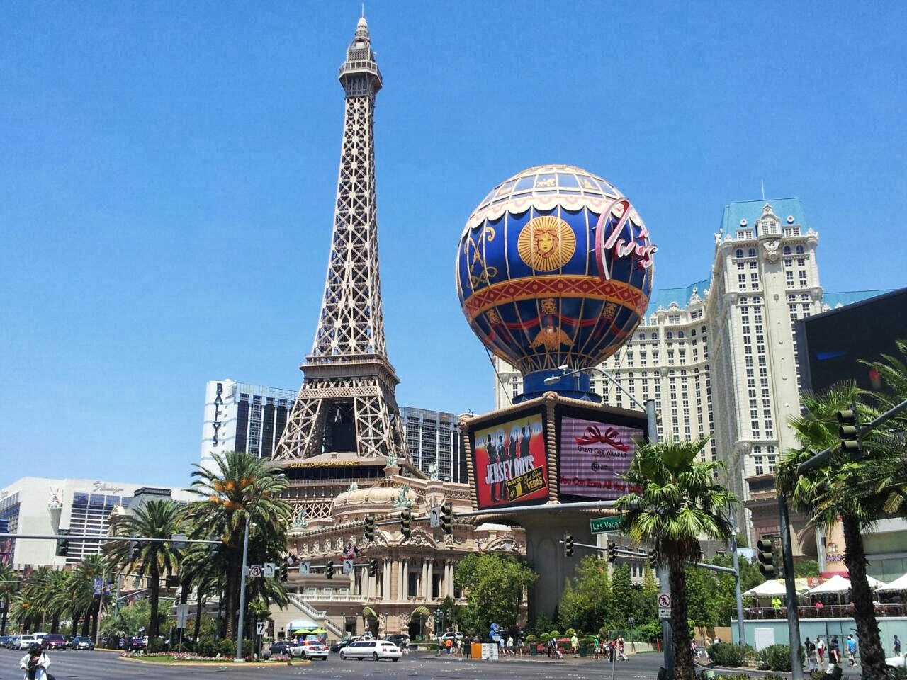
PARIS - LAS VEGAS
We departed Tusayan and said farewell to Grand Canyon. Our continued pursuit of Route 66 took us to Williams, a town which sued the government several times in an attempt to prevent its stretch of 66 being by-passed by the interstate, but finally lost. It seems to have made the best of it though, with an economy now based on tourism and Route 66 memorabilia. The same focus on memorabilia also applies to Seligman where we also stopped......a fascinatingly quirky place, though its shabbiness suggested it was struggling somewhat.

As we drove through the remaining part of Arizona we could see dust-devils dancing in the desert around us. The next stop was to see the Hoover Dam which holds back the waters of Lake Mead which, in turn, is fed by the waters of the Colorado River. Although primarily built for water storage and flood control, this huge engineering project on the Arizona/Nevada border also produces 4.2 billion kWh of electricity per annum, enough to power 400,000 homes.

The main road used to pass over the Dam, but with only two lanes it soon became a bottleneck. Security concerns were also raised following 9/11. As a consequence, a four lane road now passes over the newly constructed Mike O'Callaghan–Pat Tillman Memorial Bridge just downstream from the Dam. It was from here that we were able to view the Dam. Cars are not allowed to stop on this bridge but pedestrians can walk across once they have passed through security checks.

Now firmly in Nevada, it didn't take us long to reach the Alexis Park Resort in Las Vegas where we would stay for two nights. We were nearing the end of our Route 66 journey, so we had what would probably be our last evening meal as a group in an Italian Restaurant. Afterwards some of us did a reconnaissance of the famous Las Vegas 'Strip'. No, nothing to do with nudity! This is what might be called the Main Street in other cities. It was a Wednesday night and after 11.00pm, but the streets were full of people and brightly illuminated by the light from the huge displays that constantly advertised products. The place just throbbed with activity.

Next morning I set off on my own to walk the length of The Strip on one side of the road, then back on the other, a task that would take me all day. The hotels are much more than just places to sleep. They are also casinos, shopping malls, restaurants and theatres. Each casino/hotel links to the next by monorail or covered walkway, often bridging roads. I visited the Mandalay Bay, the Luxor, Excalibur, New York New York, then on to the Bellagio and Caesars Palace until I eventually reached the Stratosphere. I then crossed to the other side and walked back, visiting the Palazzo, the Venetian, Paris - Las Vegas and Planet Hollywood, to name just a few. The exteriors of these casino/hotels are impressive enough, showing off enormous scale-models of the Sphinx, the Eiffel Tower, the Colosseum, the Empire State Building, etc. Inside they are no less so. I was particularly awe-struck by the interior of the Luxor and Caesars Palace. In the evening I watched the fountain display in front of the Bellagio, the Volcano display at the Mirage and the Sirens of Treasure Island at the Treasure Island Casino and Hotel.

I was left with the impression that however tacky you might consider Las Vegas to be, this City certainly knows how to impress. The hotels are as elaborately and exquisitely decorated as any I have seen, and the free entertainment is better than some I have paid good money for.

As for the 'Sin' in 'Sin City', well there were a lot of scantily-clad girls around, but I didn't look - much. I didn't gamble either - promise - but I am coming back on the 7th of August so there is still time to remedy that.